 |
|||||||||||||||||||||||||||||||||||
 |
|
||||||||||||||||||||||||||||||||||
 Copyright 2007 LandChoices - All Rights Reserved |
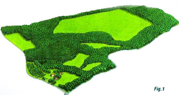
Determining Density The aerial drawing below (Fig. 1) shows how a partially wooded property looks before being developed at the full two-acre density allowed under local zoning on this 85-acre parcel, which includes 68 acres of upland without any building constraints and 17 acres of unbuildable wetlands and steep slopes. The density is calculated either on the 68 acres of buildable land or according to a common-sense “Yield Plan” demonstrating the maximum number of two-acre Following the principles of conservation design, two thirds of the property could be preserved including all 17 acres of highly constrained soils and slopes plus half of the remaining land.  Retaining Special Features Through Conservation Subdivision Design Notable elements of the site which, if designed around and saved, would add measurable value to the new neighborhood include the roadside meadow with its border of redbuds, the small orchard along the country road, the rustic stone wall, the historic house and its outbuildings, the two small interior fields, the central pasture, the stream valley habitat and parts of the woodlands. A new breed of development known as “conservation subdivisions” makes it possible for developers to preserve these value-enhancing features and for communities to protect municipal open space networks improving everyone’s quality of life At the heart of this new approach is a four-step process for laying out developments around the special elements of each property.
|
||||||||||||||||||||||||||||||||||
| Preserve Your Land | Conservation Subdivisions | Other Choices Home | About Us | News | Projects | Sponsors | Contribute | Contact Us | Links | Kids | Media Kit LandChoices • P.O. Box 181 • Milford, MI 48381 • info@landchoices.org Privacy Statement | www.landchoices.org |
|||||||||||||||||||||||||||||||||||


